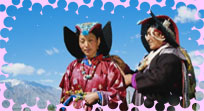
Romance in Peaks
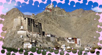
Leh-Ladakh
Ladakh also known as Little Tibet,
The Last Shangri La, The Moonland is is a land like no other. Bounded by two of the world's mightiest mountain ranges, the Great Himalayas and the Karakoram, it lies athwart two other, the Ladakh range and the Zanskar range.
In geological terms, this is a young land, formed only a few million years ago by the buckling and folding of the earth's crust as the Indian sub-continent pushed with irresistible force against the immovable mass of Asia. Its basic contours, uplifted by these unimaginable tectonic movements, have been modified over the millennia by the opposite process of erosion, sculpted into the form one sees today by wind and water.
A Virtually Rainless Area
A Virtually Rainless Area
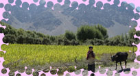
Today, a high -altitude desert, sheltered from the rain-bearing clouds of the Indian monsoon by the barrier of the Great Himalayas, Ladakh was once covered by an extensive lake system, the vestiges of which still exist on its south -east plateaux of Rupshu and Chushul - in drainage basins with evocative names like Tso-moriri, Tsokar, and grandest of all, Pangong-tso.
Occasionally, some stray monsoon clouds do find their way over the Himalaya, and lately this seems to be happening with increasing frequency. But the main source of water remains the winter snowfall. Drass (also spelt as Dras), Zanskar and the Suru Valley on the Himalaya's northern flank receive heavy snow in winter; this feeds the glaciers whose melt water, carried down by streams, irrigates the fields in summer.
For the rest of the region, the snow on the peaks is virtually the only source of water. As the crops grow, the villagers pray not for rain, but for sun to melt the glaciers and liberate their water. Usually their prayers are answered, for the skies are clear and the sun shines for over 300 days in the year.
Ladakh lies at altitudes ranging from about 9,000 feet (2,750m) at Kargil to 25,170 feet (7,672m) at Saser Kangri in the Karakoram. Thus summer temperatures rarely exceed about 270 C in the shade, while in winter they may plummet to -200 C even in Leh. Surprisingly, though, the thin air makes the heat of the sun even more intense than at lower altitudes; it is said that only in Ladakh can a man sitting in the sun with his feet in the shade suffer from sunstroke and frostbite at the same time!
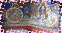
Central Ladakh
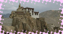
Its mural, dating from the 11th and 12th centuries, pre-date the Tibetan style of painting that is present are reminiscent of the paintings of the far off Ajanta Caves and are presumed to be almost sole survivors of the Buddhist style current in Kashmir during the first millennium AD, along with some in Phugtal Gompa in Zanskar, and Tabo in Spiti.
Northern Ladakh
Kargil, the second town of Ladakh, is situated on the Suru River just short of its confluence with the Dras-shingo. Almost equidistant, at a little over 200-km from Leh, Srinagar, Padum in Zanskar and Skardu, the capital of Baltistan, it was in the old days the centre of a network of routes joining these places. After partition, Skardu went into Pakistan, but Kargil remains the main staging-point between Srinagar and Leh, and the Gateway to the Suru valley and Zanskar.
The Suru Valley, a greatly underrated part of Ladakh, runs for about 140-km from Kargil up to the base of the Penzi-la pass into Zanskar. Although immobilized in winter by heavy snowfall, its fields, watered by streams fro the surrounding mountains, produce rich crops of wheat and barely. Traditionally, it has been an area surplus in foodgrains.
Irrigation water is plentiful enough to allow the plantation of thick stands of willow and poplar, giving the area lushness rare in Ladakh. About halfway along its length, the river loops its way past a huge mound of alluvium, the last gasp of the Zanskar range, to carry on, past the glaciers of the Nun-kun massif to Rangdum, a Gompa on a hillock overlooking a wide marshy plain.
The lower portion of the valley, its immediate charms apart, offers spectacular views of Nun-Kun and its attendant peaks. Expeditions to it mostly take off from Panikhar, the village just short of the valley's right-angled turn, which is also the base for long treks in the direction of Kashmir and Kishtwar. Other trekking bases are Sanku, further down the valley, and Rangdum.
Zanskar
Two rivers, flowing towards each other along the northern flank of the Great Himalayas, meet in the broad plain of Padum. They become the Zanskar River, which flows off northwards through a gorge in the Zanskar range, to meet the Indus at Nimo. This T-Shaped complex of valleys is Zanskar, opened to motor traffic only in 1980 when a road was built via the Suru Valley and Rangdum and over the Penzi-la.
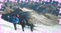
A Trekkers Paradise
Virtually untouched by the winds of change and modernization till then, Zanskar is now a favourite destination for trekkers. Padum is the centre for hard but rewarding treks to Manali via the Shingo-la (16,732 feet/5,100m); Kishtwar via the Umasi-la (17,828 feet/5,434m); and Lamayuru and Leh via difficult routes through the Zanskar range.
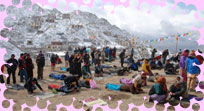
Zanskar is also known as a land of religion and has the greatest concentration of Gompas in Ladakh, outside the Indus Valley. The important ones are Sani, Karsha and Stongde in the central plain, Bardan and Phugtal just off the Padum-Manali trail, and the small hermitage of Dzonkhul on the way to the Umasi-la.
Highway
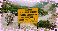
The beacon highway leads from Leh into the Nubra valley over a pass at 5,606 metres - making it probably the highest road in the world. 'You can have dialogue with god' according to the road builder's sign! Only in September and October is the road open, at other times ice covers the road on the northern side of the Nubra valley. For foreigners the road is closed year round since the Nubra valley is in the restricted area and can only be visited with special permission.
Prime Attractions of Leh-Ladakh
Zanskar
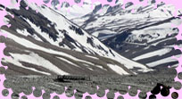
About 20-km south of Rangdum stands the Pazila watershed across which lies Zanskar, the most isolated of all the trans Himalayan Valleys. The Panzela Top (4,401 m) is the picturesque tableland adorned with two small alpine lakes and surrounded by snow-covered peaks. more.
Baralacha Pass
On the long Manali -Leh road and providing a route across the Baralacha range is the famous Baralacha Pass. It is situated at a spectacular 16,400 ft above sea level. The pass itself is 8-km long, and is literally the pass "where many roads meet".
Khardong La & Digar La Pass
The Khardong La pass is situated at an incredible elevation of over 5,800 m (18,680 ft). It lies on the route between Leh and the Shyok and Nubra valleys.
Lakes in Ladakh
The Tso Morari Lake is one of the largest lakes in Ladakh region and is almost like an inland sea. At an altitude of almost 4,500 meters, the Pangong Tso is only 8-km wide at its broadest but is an amazing 134-km long. Kyaghr lake is the halting place for trekkers moving from the Kiangdum camping ground to the Tsomorari Lake.
Nubra Glacier
The Nubra glacier is located on the southern slopes of the Karakoram Range in the Ladakh region of Jammu and Kashmir. It is a large glacier located in a huge amphitheater that is ringed by towering peaks.
River Rafting
While water levels are high, between the end of June and late August, Leh's more entrepreneurial travel agents operate rafting trips on the river Indus.
Suru Valley
The Suru Valley is formed by the catchment are of the SuruRiver, which rises from the Panzella glacier.
The Nubra Valley
The 18,640 feet high Khardung La pass forms the divide between the Nubra Valley and Leh. After crossing the Khardung La, one descends to a place called "Khalsar", situated on the left bank of the Shyok River.
Shyok Valley & Indus Valley
Indus is a large valley formed by the main channel of the Indus River as it flows across Ladakh. The Shyok Valley is the valley of the Shyok River -- the river of death. This is a "Yarkandi" (Central Asian) name, probably given by the Central Asian traders.
How to Reach Leh-Ladakh
Moving On
As befits India's remotest Himalayan town, Leh is singularly hard to get to, and even harder to leave. Fragile road and air links mean visitors all too often find themselves stranded waiting for passes to open or planes to appear. Wherever and however one travels, book an onward ticket as far in advance as possible and be prepared for delays if the weather changes.
By Road -
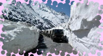
The main overland approach to Ladakh is from the Kashmir Valley via the 434-km Srinagar-Leh road, which remains open for traffic from early June to November. The most dramatic part of this road journey is the ascent up the 11,500 feet /3,505 m high Zoji-la, the passing the Great Himalayan Wall that serves as the gateway to Ladakh.
The J&K State Road Transport Corporation (J&KSRTC) operates regular Deluxe and Ordinary bus services between Srinagar and Leh on this route with an overnight halt at Kargil. Taxis, cars and jeeps are also available at Srinagar for the journey. Groups can charter deluxe and A-class buses for Leh, Kargil or Padum (Zanskar) from the J and K SRTC at Srinagar.
Since 1989, the 473-km Manali-Leh road has been serving as the second land approach to Ladakh. Open for the traffic from around mid-June to early October, this high road traverses the upland desert plateaux of Rupshu whose altitude ranges from 3,660m to 4,570m.
A number of high passes fall en route among which the highest one, known as Taglang-la, is the world's second highest motor able pass at an altitude of 17,469 feet/5,325m. H.P. Tourism, H.P. SRTC and J&K SRTC operate Deluxe and Ordinary bus services between Manali and LEH. The bus journey between Leh and Manali takes about 19 hours or two days with an overnight halt in camps at Serchu or Pang. Gypsy and jeep taxis are also available, both at Manali and Leh.
By Air -
The quickest way out of Ladakh region is by plane. Airline service operates regular scheduled flights to Leh from Delhi, Chandigarh, Jammu and Srinagar. Some private airlines are also planning to operate air services betwe4n Delhi and Leh in the near future.
Climate of Leh-Ladakh
Weather of The Cold Desert Ladakh lies at altitudes ranging from about 9,000 feet (2,750m) at Kargil to 25,170 feet (7,672m) at Saser Kangri in the Karakoram. Thus summer temperatures rarely exceed about 270 C in the shade, while in winter they may plummet to -200 C even in Leh. Surprisingly, though, the thin air makes the heat of the sun even more intense than at lower altitudes; it is said that only in Ladakh can a man sitting in the sun with his feet in the shade suffer from sunstroke and frostbite at the same time!
Clothing
Zanskar experiences drastic fluctuations in the daily temperature even during the height of summer. While the days are pretty warm, even hot at times due to the desertic effect, the evenings can become quite chilly thus requiring additional clothing. It is advisable to be prepared for this situation with a pullover and a down jacket. Other essential items include a sturdy pair of walking shoes, a good sleeping bag, and a pair of woolen socks or some thick cotton socks. It is also essential to bring a quality tent if the intention is to travel or trek around on your own, and a good quality rucksack for back packing. It is also important to carry your provisions from Srinagar or Kargil, if a longer tour of the adjoining villages is intended.
Best Time to Visit Leh-Ladakh
June To Mid September
Trekking Season: May To Mid-October
Mountaineering Season: Mid-May To Mid-October
What to Do in Leh-Ladakh
The climbing season extends from mid - May to mid -October, the ideal period being from June to September because during this time only Ladakh remains unaffected by the monsoon, which holds sway over most of the Himalayas. Foreign climbing expeditions are required to obtain permission from the Indian Mountaineering Foundation for climbing all listed peaks. A booking fee, based on the height and popularity of the allotted peak, is charged and a Liasion Officer is assigned to every climbing team. The minimum period required for processing applications is six months. Every authorized expedition is provided with adequate rescue coverage in the events of accidents and illness.